
Site selection
The fastest way
to find locations
that work.
Search by zoning and property criteria, validate against real-world constraints, and move forward with confidence.
Trusted by:

How it works
Every inquiry is an opportunity.
In a competitive site selection landscape, you aren’t just looking for land or available properties, you're looking for certainty and speed-to-market.
Make your job easier
Search. Assess. Report.
Search entire municipalities by permitted use, dwelling type and lot criteria. Assess surrounding GIS features, like Official Plans, nearby highways, and flood zones. Then create professional reports with a click of a button.
Govern your data
Brand your public portal.
Launch a branded portal on your website so residents, investors, and site selectors can explore your municipality by their criteria, while staff retain secure access to internal and private layers.
LandLogic’s site selection capabilities has been a game-changer for us. It saves our team countless hours compared to manual reviews. What used to take us days of cross-referencing multiple systems and spreadsheets now takes minutes. We can assess opportunities faster, and for a firm working on complex sites where every detail has an impact, the time savings and informational clarity are invaluable.

Amin Sarang, CEO
DEVNEX Solutions Inc.
Built for your team
Why your team will love LandLogic.
Whether you’re responding to inquiries or advising clients, LandLogic helps teams move from criteria to confident decisions faster and with greater clarity.

Economic Development
Site Selectors
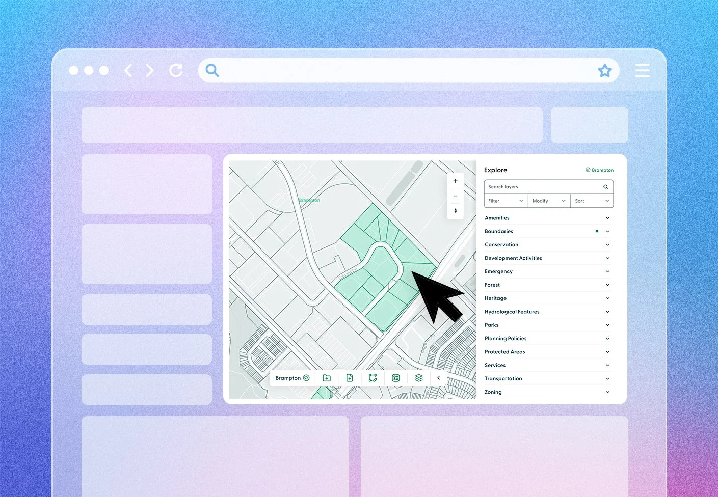
One place to research
Zoning, policy, and GIS in a single, searchable platform.
Turning a lead into an investment can take weeks of chasing maps and PDFs across planning and zoning departments. LandLogic eliminates that grind.

Filter by intent
Instantly search by permitted use, dwelling type and zoning criteria.
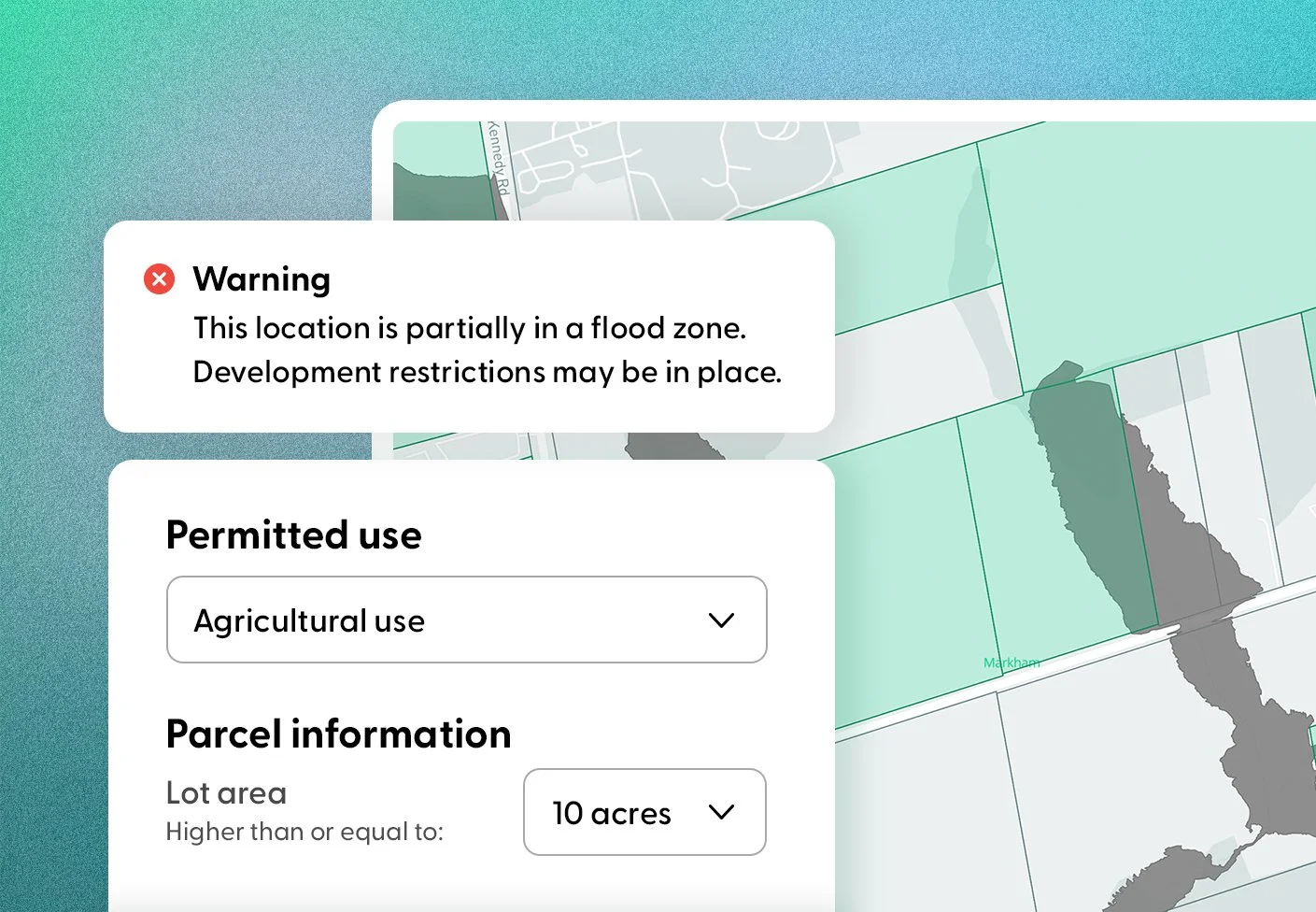
Validate suitability
Test against 850+ datasets, like road access and environmental risks.
Get reports instantly
Get custom branded zoning, site assessment or demographic reports.
Move faster. Work smarter.
Built for research speed, accuracy and defensible insights.
Replace manual research with one property intelligence platform that brings zoning, policy, and GIS data together in minutes.
Search
Enhanced filtering.
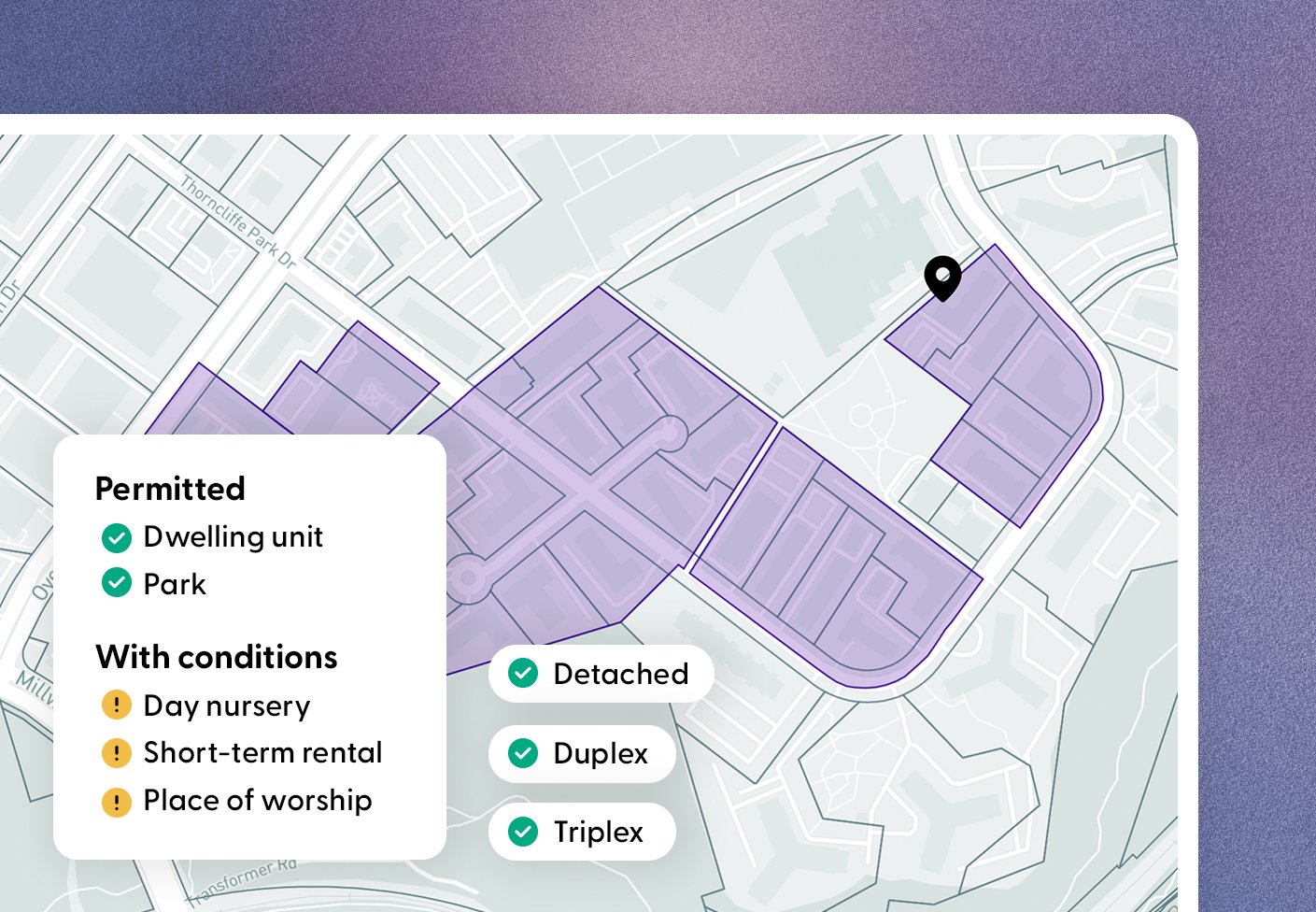
Go beyond static mapping. Search properties by permitted use, dwelling type, and zoning criteria to see exactly what's possible with any location.
-
Instantly identify land where a specific industry is already a permitted use. Or simply identify the potential for a re-zoning application.
-
Narrow down your search by filtering by lot size, frontage, depth and more to match exact project requirements.
Assess
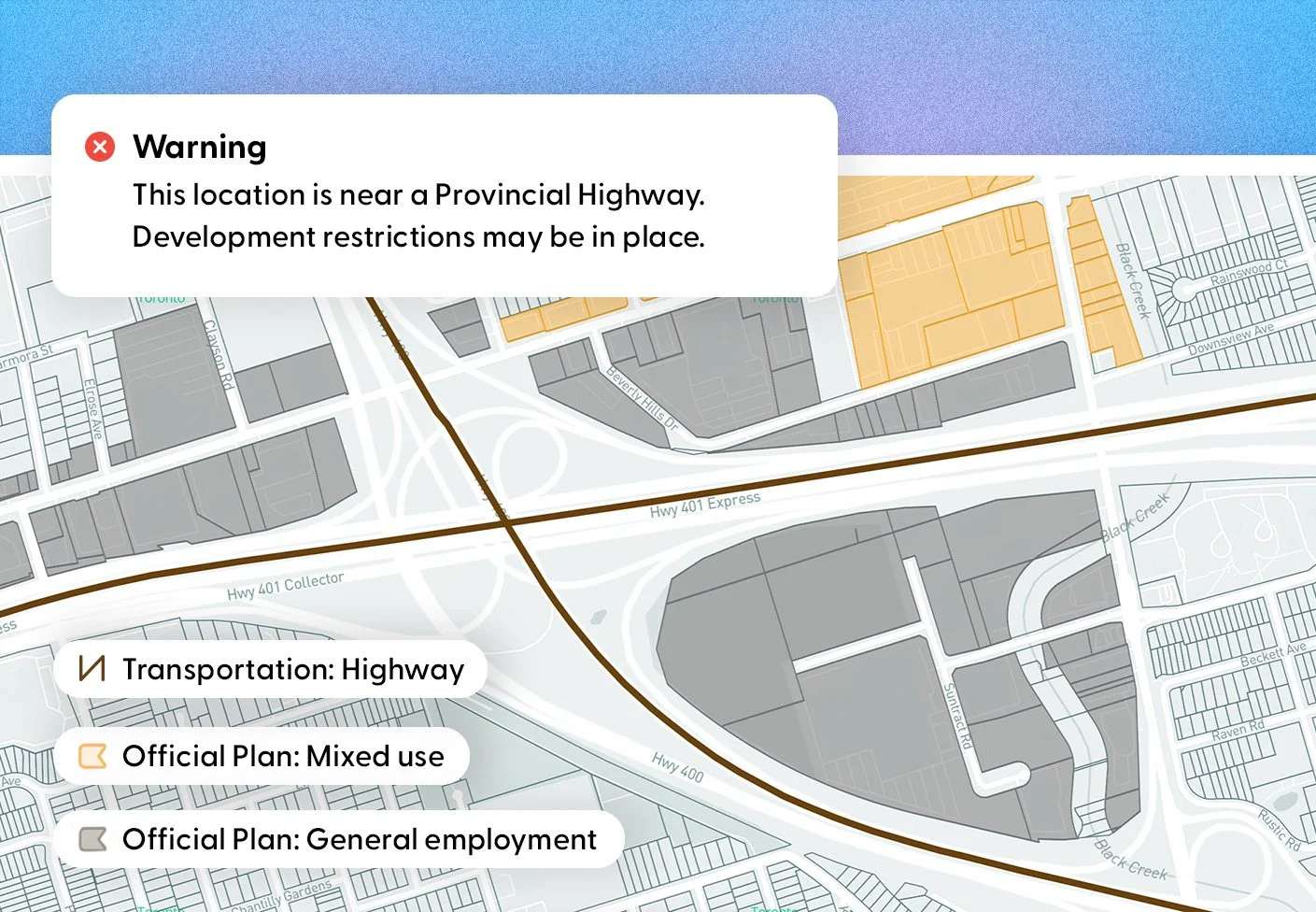
Check for risks and opportunities.
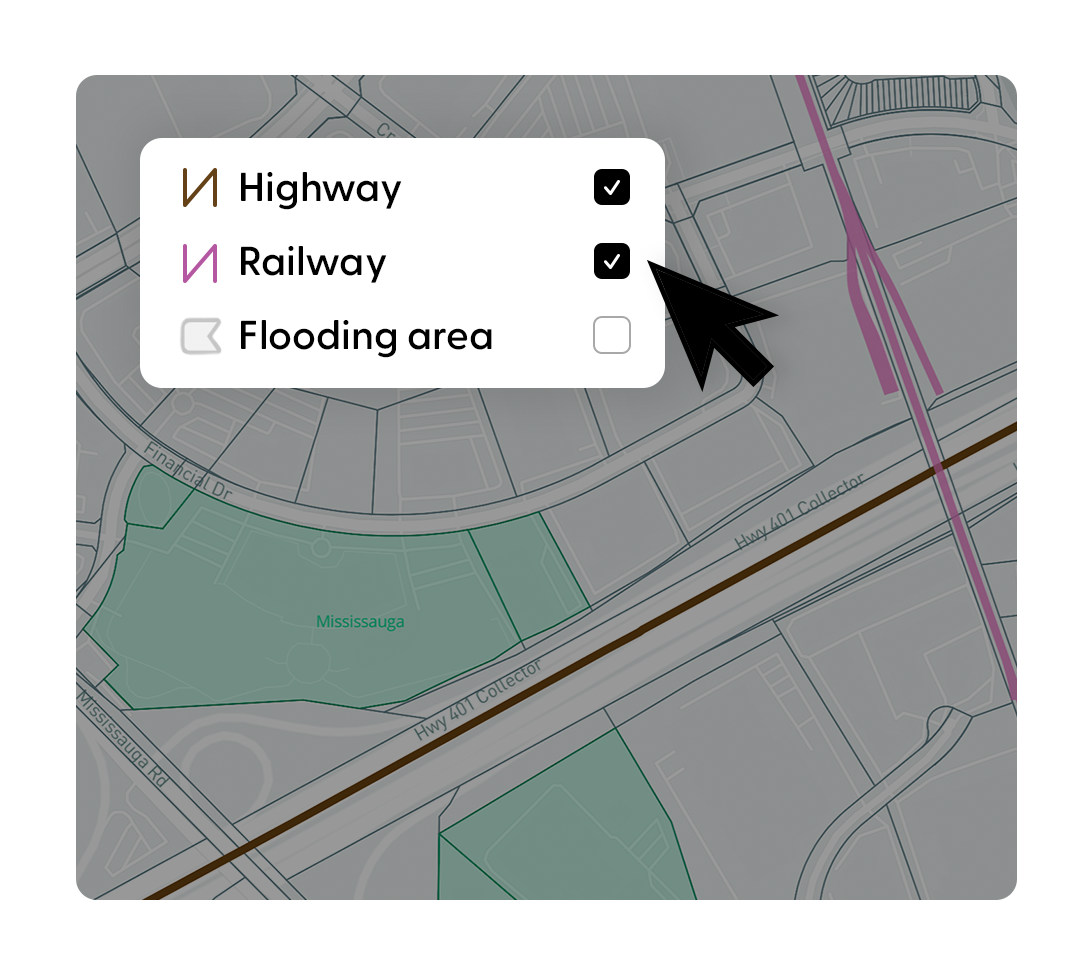
Over 850 GIS datasets help assess zoning, policy, and constraints—deployed as an internal platform or a branded public portal.
-
Interact with hundreds of spatial layers instantly on an dynamic map to easily assess which factors impact risk and viability of a site.
-
Easily switch on the data that applies to you, like official plans, urban boundaries, railways, road access, development activity, and more.
-
We can onboard your municipality’s unique datasets and securely connect your internal and private layers so your team has access to the most up-to-date intelligence in one place.
Report
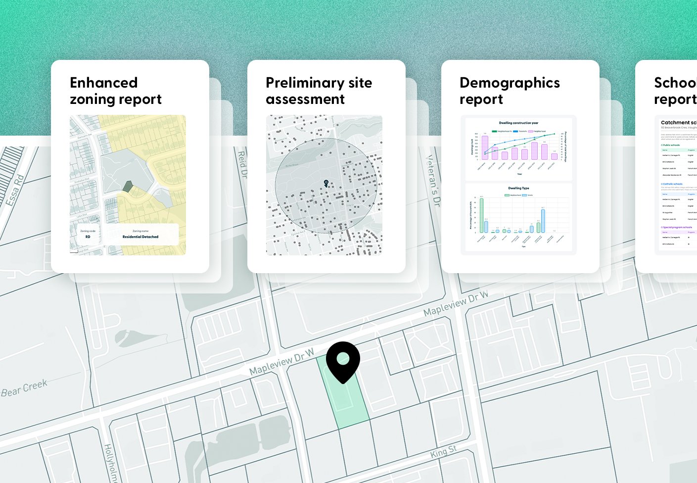
Professional reporting.
Create reports with your own branding that support fast inquiry responses, investor discussions and confident site selection.
-
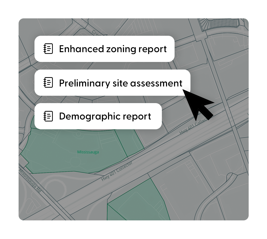
Download a zoning report for permitted uses and dwellings, requirements, measurements and additional considerations so teams can answer feasibility questions with confidence.
-
Download a preliminary site assessment to quickly evaluate opportunities and risks before advancing a site—including zoning constraints, floodplains, and conservation.
-
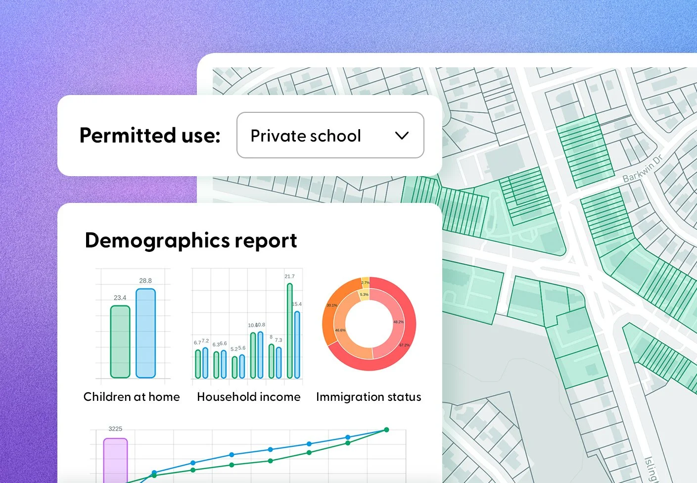
Access demographic and community profiles for any address to support business attraction, market analysis, and location decisions.
-
School zones and ratings have a huge impact on property decisions. Now that info is easy to access: just search an address, download, and see catchment, ratings, languages, special programs, and more.

FAQ
Answering all your questions.
We’ve answered some of the questions that we get the most, but if you have a more specific query, don’t hesitate to contact us.
-
Let’s look at a scenario to explain how it works:
The scenario: An advanced manufacturing company submits an inquiry asking whether your community can support a 20-acre site with appropriate industrial zoning, transportation access, and no major environmental constraints.
Today: Your team spends days (or longer) tracking down answers across planning, zoning, engineering, and GIS, waiting on confirmations about permitted uses, parcel dimensions, and site constraints, before you can confidently respond. All while the company is actively evaluating multiple jurisdictions.
With LandLogic: In minutes, your team filters the municipality by permitted use, lot size, and real-world constraints, then delivers a clear, professional response backed by data. You respond faster, with confidence—and keep the opportunity moving forward.
-
Let’s look at a scenario to explain how it works:
The scenario: A global logistics firm provides a clear set of requirements: a 20-acre site, industrial zoning, and proximity to a 400-series highway.
Today: You translate those requirements into dozens of outreach emails and calls to economic development organizations across multiple jurisdictions—each with different data formats, response times, and levels of detail.
While responses trickle in, your team spends days validating information, reconciling inconsistencies, and determining which locations are even worth advancing to the next round.
With LandLogic: Before initiating outreach, you independently screen jurisdictions against your client’s criteria—filtering by permitted use, lot size, and highway access, and validating sites against real-world constraints.
In minutes, you identify a focused shortlist of qualified locations—allowing you to engage economic development organizations with precision, reduce back-and-forth, and move the process forward with speed and confidence.
-
LandLogic aggregates and standardizes a broad range of zoning, planning, environmental, GIS, demographic, and land-use data into one unified platform. This includes digitized zoning by-laws and permitted uses, Official Plan layers, parcel attributes, transportation access, environmental constraints, utilities, demographics, and hundreds of additional GIS datasets that impact site feasibility.
What makes this different is not just the volume of data, but how it’s structured. All datasets are normalized and logic-driven, meaning you can search, filter, and validate sites by intent, not just view static maps. The result is a single, reliable source of truth for answering real-world site selection questions quickly and consistently.
To see all the data available to you, create a free 3-day-trial account to explore our data up close.
-
LandLogic gathers all of our data from official data sources under open data policy (such as municipalities, conservation authorities, regions, provinces, etc.), and updates it’s information as soon as new policies are published. This ensures that zoning rules, policies, and constraints are represented accurately across jurisdictions.
When data is unavailable from the municipality, or is undergoing current revisions, that is clearly indicated in LandLogic’s reports, so there is no confusion about what information is the most recent or more accurate.
And in instances where additional approvals, overlays, or constraints may apply, those conditions are clearly marked so teams can respond with confidence and transparency. This reduces risk, eliminates guesswork, and builds credibility with Economic Developers and Site Selectors who expect defensible answers.
-
LandLogic can be deployed as a branded public portal that integrates directly into your existing website. Residents, investors, and site selectors can explore opportunities on your website using the same zoning-accurate intelligence your internal teams rely on, while staff retain secure access to internal, private, or restricted data layers.
The platform is configurable to your policies, datasets, and branding, and does not require changes to your existing systems. This allows municipalities to modernize service delivery, improve transparency, and reduce repetitive inquiries without increasing staff workload.
-
LandLogic generates professional, investor-ready reports that are designed for site selection and economic development workflows. These include zoning summaries, preliminary site assessments, demographics and school reporting.
Reports can be shared internally or sent directly to investors and other site selectors. Because they are generated from live data, teams can respond to inquiries in minutes instead of days, with outputs that are clear, consistent, and defensible.
Learn more about our reports on the Data Studio page.
-
Traditional GIS platforms are built for showing data visually on a map. But that only works for one format of data, from one jurisdiction at a time. The insight into that data is limited, because it has only been designed to be accessed in limited ways.
LandLogic goes much further than that. We collect property data saved in different formats from different municipalities and unify it. We take all that differing data and reformat it into one, single database.
This allows us to provide next-level property analytics tools, like site selection. So instead of just visualizing a flat layer on a map, you can search, analyze, compare and customize how you interact with that data.
-
The general LandLogic subscription does not currently provide real estate data. We focus on the intelligence required to assess feasibility and suitability at the earliest stages, before transactions occur.
That being said, LandLogic is always working to add additional datasets for our users. But before we can do that, we need to ensure strict accuracy and compliance is in place, as real estate data has its own unique usage limitations.
To stay tuned on when real estate data may come to the platform, subscribe for updates!

Create an account instantly to get started today, or contact us to get a demo of any of our tools